
Accuweather.com — A weather battle zone will continue to take place as winter fights back in the northeastern United States with areas of flooding rain, dangerous ice and a blanket of heavy snow through Friday.
The multifaceted storm will continue to affect the region just days after springlike warmth surged in. It is the same storm system responsible for heavy snow over the southern Plains on Wednesday and flooding and severe weather in the South.
Mild conditions will hold along the mid-Atlantic coast and in southeastern New England, but cold air that recently returned to the interior Northeast is having wintry consequences across parts of the central Appalachians and the northern tier.
Copious amounts of moisture are being wrung out by the strengthening storm system. Enough precipitation either in the form of rain, ice or snow is forecast to cause travel disruptions over a broad area.
The storm brought a soaking rain from Roanoke and Richmond, Virginia, to Washington, D.C., Baltimore, Philadelphia and New York City during Thursday afternoon and night. Another period of rain will swing through these areas during Friday morning before it dries out in the afternoon.
As winds pick up behind the rain and the storm lifts to the north, the saturated state of the ground can cause an unusually high number of trees to topple in the mid-Atlantic and southern New England regions on Friday.
Sporadic power outages and property damage can occur. People should avoid standing under or parking under trees in this situation.
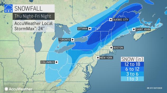
For the northern tier of the Northeast, there will be an all-out snowstorm into Friday night, according to Chief On-Air AccuWeather Meteorologist Bernie Rayno.
Snow was beginning to fall in earnest across the upper Ohio Valley early Friday morning, with snowfall rates predicted to be 1 inch per hour or higher.
This band of heavy snowfall will continue to pivot northeastward throughout the day on Friday.
“A general 6-12 inches of snow will fall in the swath from parts of northwestern and north-central Pennsylvania to central and northern Maine but a 12- to 18- inch band is in store farther over the northern tier of the Northeast where an AccuWeather Local StormMax™ of 24 inches is likely,” Rayno said.
As the big snowstorm ramps up over the northern tier of the Northeast, people who live in or travel through Ohio to northern Massachusetts should not write off the storm’s snowfall. Enough snow to blanket roads and shovel and plow is likely over the central Appalachians.
“Even in part of this area, it may snow hard, at the rate of 1-2 inches per hour for a time during Friday morning and midday,” Rayno said. “Roads could go from wet to slushy to snowcovered in minutes as the storm picks up.”
These rapidly changing conditions will be a concern for motorists along portions of I-68, I-70, I-76, I-77, I-79, I-80, I-81, I-86, I-90 and I-99. Cities that could be hit hard and fast by snow on Friday include Pittsburgh, Dubois and State College, Pennsylvania; Morgantown, West Virginia; and Youngstown, Ohio.
As temperatures surge to record high levels in the 50s F along the mid-Atlantic and New England coasts for a time on Friday, snow showers will be frequent enough to cover the ground in portions of southern Ohio, Kentucky, Tennessee, West Virginia and western Maryland before the week concludes. Roads could become slippery as a temperature drop into the 20s can lead to a quick freeze in some locations.
A few inches of snow can pile up in the mountains as far south as those bordering West Virginia and Virginia.
In the wake of the storm, colder air will spill into parts of the interior South and along coastal areas of the mid-Atlantic and southern New England.
This may be an important factor, depending on the strength of a small storm that will race eastward from the Central states this weekend.
If that storm remains weak and moisture-starved, only spotty flurries will streak out from parts of the Ohio Valley Saturday to the central Appalachians, mid-Atlantic coast Saturday night and southern New England early Sunday.
On the other hand, if that storm ends up being a tad slower and stronger, it could put down a swath of light to moderate snowfall in the same zone.

Be the first to comment on "Storm unleashing a barrage of precipitation across northeastern U.S."