
“The land that we live on, namely Tioga County, N.Y., as it exists today has not only been changed by progress, but it has changed ownership, and even nationality, many times in the last five centuries. Of course, throughout most of human history, the principal occupants of the area were evolving groups of native indigenous people.”
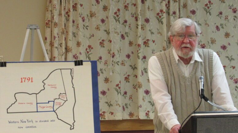
Historian Tom McEnteer was the guest speaker at the Candor Historical Society’s March 1 talk that enlightened the audience with a top-notch history lesson on the development of Tioga County. Highlighting many of the transfers of the land from state to state, and then from county to county over the ensuing years, with maps of the various details to illustrate them, McEnteer also recounted the local land arrangement that was purchased directly from the local native tribal leaders by James McMaster, with the help of Amos Draper.
“The records of that deal are a bit too sketchy to know why or how the deal took place, or how fair it was, but an actual legal deed was produced. The McMaster purchase ended up being the portion of what is now the Town of Owego, which includes the Village of Owego.”
Other land-grant purchases ensued. The Boston Purchase, which included 230,000 acres of land between Owego Creek and the Chenango River. Two speculators named John Watkins and Royal Flint purchased the land encompassing 363,000 acres. Their land included territory west of the Owego Creek as far as Corning, from the Susquehanna River north to the Finger Lakes, and was sold to prospective settlers. Then, in 1775, the Coxe family was granted close to 30,000 acres between the Susquehanna River and the Pennsylvania line, including most of what are now Apalachin and the Town of Nichols.
According to McEnteer, in 1791 a larger mapping shows Tioga County’s various divisions through 1836.
“Parts of the original Tioga County were taken off to help form Onondaga County (1794), Chenango County (1798), Broome County (1806), Tompkins County (1822), and Chemung County (1836). The Onondaga portion was subsequently broken into other pieces that became counties. Here in the Southern Tier, Tioga County became known as the ‘Mother of Counties.’”
McEnteer’s talk concluded with the current mapping statistics of Tioga County.
“In 1791, when Tioga County was formed as New York State’s 20th county, it included about 3,000 square miles. After losing pieces to six other counties over the years, Tioga County is now down to only 525 square miles left.”
To view McEnteer’s entire talk, you can visit the Candor Historical Society’s Facebook Page at www.facebook.com/candorNYhistory.
For more information about the Candor Historical Society and to see what other programs are available, email to candorhistoricalsociety@weebly.com.

Be the first to comment on "Candor Historical Society Talk; Our Land has an Elaborate History"